
Citizen urbanism
Public consultation in urban planning reinvented with in situ interactive and augmented visualization

Promote civic engagement and gather opinions with our innovative platform and augmented reality
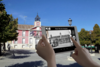
Development projects require active public participation to guarantee their success and acceptability. With OHRIZON's public consultation solutions, we reinvent citizen engagement through interactive tools such as augmented reality, immersive 3D visualizations to discover in situ, interactive augmented reality floor plans and real-time surveys. Offer your citizens inclusive and transparent public participation, while complying with environmental code requirements.
Why choose OHRIZON for your public planning consultations?
Interactive and accessible visualization
Simplify floor plans with interactivity and augmented reality
Increased citizen participation
Accessibility and transparency
Implementation process with OHRIZON
Our solutions for public consultations
1. 3D and interactive visualizations
- Creation of interactive models to simulate the impact of projects on urban and natural spaces.
- Integration ofvirtual elements for real-time visualization of on-site layouts.
2. Enhanced floor plans
- Interactive maps allow citizens to click on specific areas to obtain detailed information.
- Ideal for presentingland development projects or the environmental impact of classified installations (ICPE).
3. Collecting and analyzing citizen feedback
- Integration ofconsultation notices via surveys or electronic forms.
- Synthesis of public comments to guide project adjustments.
Examples of projects
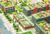
Development of a sustainable neighborhood
Use of 3D visualizations and an augmented reality floor plan to show future green spaces and housing.

Extension of a public park
Real-time surveys to adjust the project according to the needs expressed by local families.
Rehabilitation of a historic center
Interactive augmented reality plans, in situ visualization, consultation with residents to explain architectural and environmental impacts.
Modernize your consultation procedures and engage citizens in the positive co-construction of your urban and environmental projects.
Immersive augmented reality
Our unique immersive augmented reality technology manages depth,occlusion and rendering in real time, while guaranteeing interactivity and fluidity !
Platform for creating and publishing
Create unforgettable active training courses and unique immersive sightseeing tours for all audiences, and for both group and independent use.
3D characters and architecture
Historical reconstructions, realistic 3D plans, animated avatars and friendly mascots - our 2D and 3D artists create unique immersive worlds!
Supporting our team
Our team of experts will work with you to imagine and create the best interactive scenarios to make your projects attractive, useful and sustainable ,